
I
My website has updated information:
http://www.nextstagegauges.com/ns1-gauge-system
I've watched folks drooling over the new Polaris gauge and its lackluster mapping and lack of features for far too long now. I've been working on a gauge that can completely replace the OEM gauges on Arctic Cat, Yamaha, and Polaris since early this year, and it's probably about time to get some feedback. The current version of the hardware is actually using the firmware from the Deluxe Gauge Reflash that is already available for Arctic Cats. I'd like to hear about features the people think are missing from what I've laid out below. The mapping portion of the software I will be releasing on Android so that people can use with it on smartphones this winter.
The important features of this gauge are the following:
General Functionality:
-Android operating system, all Android applications can be run
-Bluetooth and WIFI connectivity
-Around 16GB of storage
-Large 7inch LCD screen that is readable in sunlight
Mapping Functionality:
-Satellite imagery
-Topographic maps
-Topographic contour lines on top of other maps
-Snowmobile Trails on top of other maps
-Tracks and Waypoint support using GPX files
-Tracks and Waypoints using KML files
-Built-in ability to cache maps for offline use
-Download packs of cached maps for an area (like satellite imagery for Snowies)
Gauge Functionality:
-5 gauge layouts that can switched between
-Each gauge layout can be edited
-Different styles and sizes of gauge faces
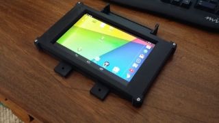
I will be doing beta testing this winter with the gauge on Arctic Cat sleds using some temporary hardware (actually based on a Nexus 7 tablet). I have a waterproof enclosure built for it, and at the moment I'm working on the mount for the gauge. The eventual hardware for the gauge will almost certainly be using a resistive touchscreen for use in cold weather and snow, but I've also built in support for gamepads. This will allow handlebar controls on the gauge, including the mapping features. I'm guessing that the price will fall in the $500 to $700 range, but don't quote me on that.
Another thing I'm working on, which is why this gauge isn't available this year actually, is a GPS transponder system. It works much like a Garmin Rino where it transmits your location and allows you to see other people's locations. It will however work much better since it will be operating on frequencies where it can constantly be transmitting your location instead of at most once a minute. The GPS transponder actually shows the information right on the map of the gauge's software.
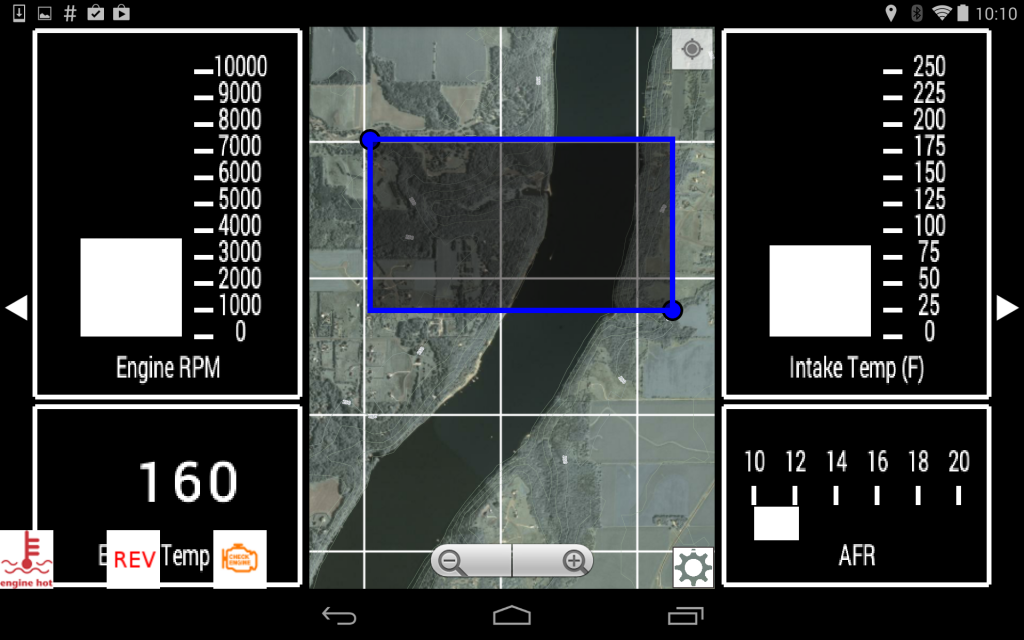
Below are a few screen shots of the software:
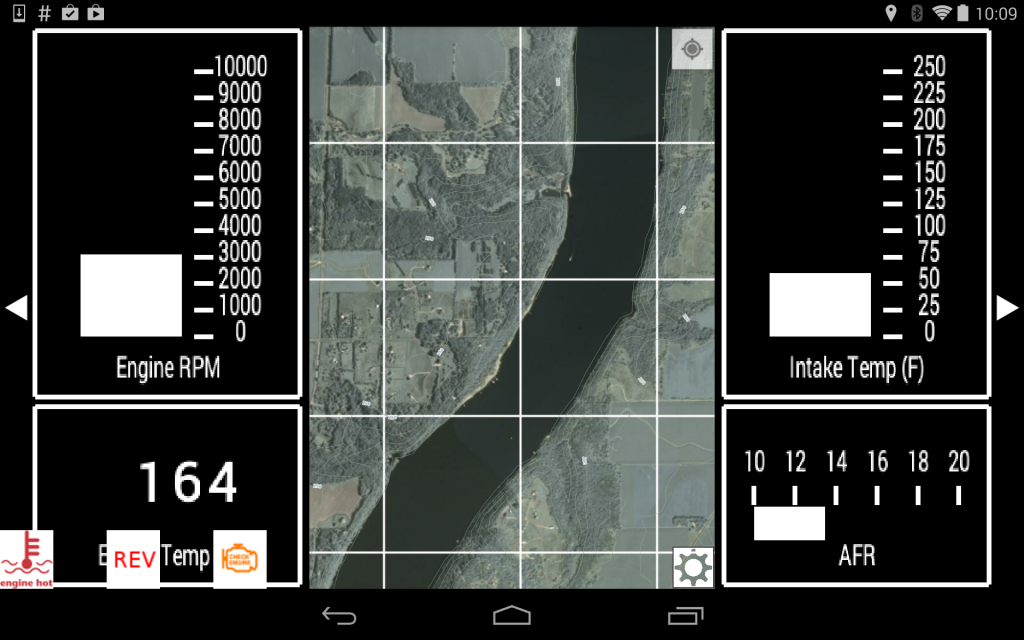
Satellite imagery with contour lines (contour lines will be thicker than shown below):
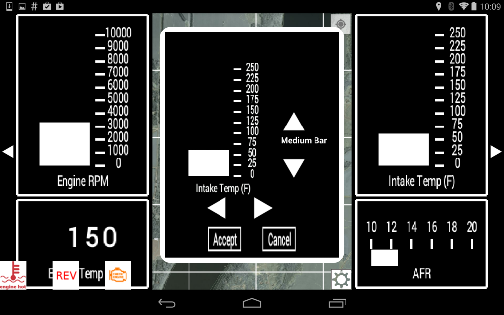
Editing a gauge layout:
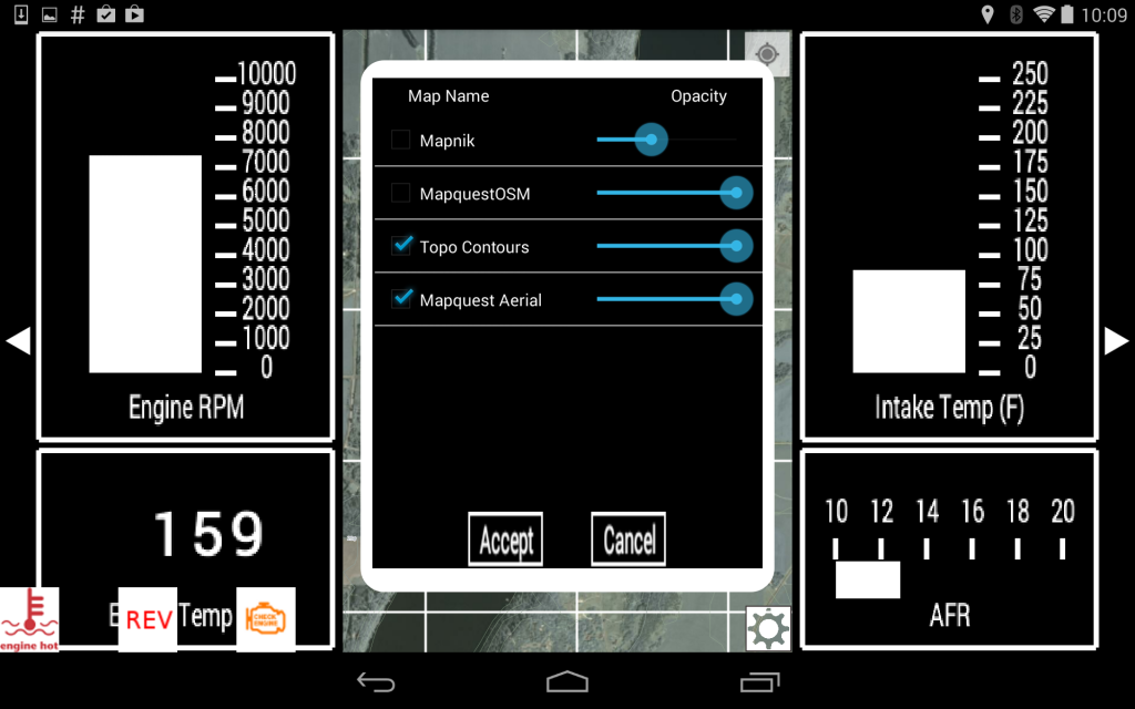
Controlling the layers visible on the map:
Selecting an area to be cached:
http://www.nextstagegauges.com/ns1-gauge-system
I've watched folks drooling over the new Polaris gauge and its lackluster mapping and lack of features for far too long now. I've been working on a gauge that can completely replace the OEM gauges on Arctic Cat, Yamaha, and Polaris since early this year, and it's probably about time to get some feedback. The current version of the hardware is actually using the firmware from the Deluxe Gauge Reflash that is already available for Arctic Cats. I'd like to hear about features the people think are missing from what I've laid out below. The mapping portion of the software I will be releasing on Android so that people can use with it on smartphones this winter.

The important features of this gauge are the following:
General Functionality:
-Android operating system, all Android applications can be run
-Bluetooth and WIFI connectivity
-Around 16GB of storage
-Large 7inch LCD screen that is readable in sunlight
Mapping Functionality:
-Satellite imagery
-Topographic maps
-Topographic contour lines on top of other maps
-Snowmobile Trails on top of other maps
-Tracks and Waypoint support using GPX files
-Tracks and Waypoints using KML files
-Built-in ability to cache maps for offline use
-Download packs of cached maps for an area (like satellite imagery for Snowies)
Gauge Functionality:
-5 gauge layouts that can switched between
-Each gauge layout can be edited
-Different styles and sizes of gauge faces
-Horizontal Needle
-Vertical Needle
-Horizontal Bargraph
-Vertical Bargraph
-Text/Numbers
-Can show many different types of data-Vertical Needle
-Horizontal Bargraph
-Vertical Bargraph
-Text/Numbers
-RPM
-Speed
-GPS Speed
-Altitude
-Engine Temp
-Intake Temp (on Arctic Cat)
-Voltage
-AFR (must have an AFR sensor)
-Boost (must have a MAP sensor on the sled)
-Speed
-GPS Speed
-Altitude
-Engine Temp
-Intake Temp (on Arctic Cat)
-Voltage
-AFR (must have an AFR sensor)
-Boost (must have a MAP sensor on the sled)
I will be doing beta testing this winter with the gauge on Arctic Cat sleds using some temporary hardware (actually based on a Nexus 7 tablet). I have a waterproof enclosure built for it, and at the moment I'm working on the mount for the gauge. The eventual hardware for the gauge will almost certainly be using a resistive touchscreen for use in cold weather and snow, but I've also built in support for gamepads. This will allow handlebar controls on the gauge, including the mapping features. I'm guessing that the price will fall in the $500 to $700 range, but don't quote me on that.
Another thing I'm working on, which is why this gauge isn't available this year actually, is a GPS transponder system. It works much like a Garmin Rino where it transmits your location and allows you to see other people's locations. It will however work much better since it will be operating on frequencies where it can constantly be transmitting your location instead of at most once a minute. The GPS transponder actually shows the information right on the map of the gauge's software.
Below are a few screen shots of the software:
Satellite imagery with contour lines (contour lines will be thicker than shown below):

Editing a gauge layout:

Controlling the layers visible on the map:

Selecting an area to be cached:

Last edited:
") .
.